Phytosociological evaluation of the different plant communities of Highlands Wilderness as basis for an ecological management plan
Introduction
It is of great importance before drawing management plan to know the objectives of the rancher. To be able to manage a game farm one has to be familiar with the vegetation of the area. Knowledge of the vegetation is the first step in compiling a management plan while it provides the information needed to keep animals in such a way that the veld does not deteriorate. With this knowledge strategies can be made to manage the area in the best way possible. Vegetation provides the food and shelter for animals and it protects the soil against erosion. Therefore, it is essential for environmental planning and it should be kept on a stable healthy level. Vegetation around the world is not similar in species composition and structure.
On every single ranch or reserve, a whole mosaic of different homogeneous plant communities is usually found. According to Van Rooyen and Theron (1996) vegetation types or plant communities are units with the same plant species composition and structure and thus the same palatability, production potential and grazing/browsing capacity. It is important to differentiate these units on any particular piece of land and manage these units on any particular piece of land and to manage these units according to their individual characteristics. In this manner it can be pointed out that no piece of land can have uniform potential to sustain certain number of wildlife, but rather that every homogenous units has its own potential, which differ from the other communities on the same property. This must be taken into account when setting objectives and formulating a management plan.
Primary succession is initiated on bare areas such as rock surfaces, or in a newly formed pond of water, where no vegetation has grown before. If the pioneer community becomes established on a wet substrate, such as a gradually filling bog or swamp, then the invasion is a hydrarch (wet) primary succession. Secondary succession occurs wherever plant community has been disturbed and is no longer in equilibrium with its environment, but where, at least, some residual effects of previous occupation of plants remain (Tainton and Hardy 1999). The disturbance can be natural, or induced by man. First community to establish in an area is known as the pioneer plant community. The species in the pioneer community are usually adapted to severe conditions. This gives them the opportunity to establish themselves (Tainton and Hardy 1999). Plant communities follow each other in a certain pattern.
Each community can be seen as a stage in succession. These plant communities are known as succession or seral communities. Successional communities will replace each other until a climax community is reached. The entire progression of the different succession communities from the first to the climax community is called succession or a sere (Barbour 1987). Succession is driven from simple ecosystems towards more complex ecosystems with more trophic levels and greater diversity of species and life forms. The modern view of vegetation change emphasises the importance of repeated, relatively frequent disturbance and accepts continuous change in vegetation as the norm (Glen-Lewin, Peet and Vebelen 1992). This allows the manager to follow an active adaptive management plan as stated by Stuart-Hill (1989).
According to Stuart-Hill (1989), adaptive management is the term used to describe the system of making management decisions by learning from one’s past mistakes and successes. The continuous monitoring and keeping records for basis of an active adaptive management plan. The availability of food in each plant community changes is not stable through out the year due to change in seasons. Plants grow according to seasonal cycle, which is of great importance for an ecological management plan. Phenology is the term used to describe the different growth phases or phenophases in the life cycle of plants and animals that occur in reaction to the climatic rhythm of the environment (Van Rooyen and Theron 1996). Phenophases like leaf, flower, and different fruit phases of grasses, forbs, and trees are usually repeated at the same time every year. This is the reason that monitoring of the different homogeneous plant communities must also be done at the same time every year.
In order to practice sustainable management, without deterioration of the veld, it is important to know the species composition and abundance of all homogenous plant communities as well as the approximate area covered by each community on the ranch. Another problem associated with the calculation of the grazing/browsing capacity on a ranch is the fact that all plants are not eaten at the same rate. Other animals show preferences towards certain plants, while other plants are preferred by a number of different animals. A sound knowledge of the plant composition is thus important. The plant community scale is important because populations and individuals of a plant species can be identified and grouped together to characterise the vegetation of an area of a few square metres to several square kilometres. It is at this scale that humans can make best sense of nature and variation of vegetation cover. Conservation and management activities may be applied at this scale. Braun-Blanquet is used to construct a global classification of plant communities (Kent and Coker 1996).
Objectives
The aims of the study are as follows:
- Identify homogenous units on the study area
- Identify all the plant species present in every community
- Classify every homogenous community structurally
- Identify rare and endangered plant species
- Identify ecologically sensitive areas
- Literature study
The veld on a ranch is usually heterogeneous with different distinct units in regard to plant species composition (Van Rooyen and Theron 1996). It is essential to identify these distinct units before any management plan can commence. According to Kent and Coker (1992), the method of vegetation description applied in a particular project will depend on the purpose of the study, scale of study, overall habitat type and the resources available. The process of recognising and defining plant communities is known as phytosociology.
According to Kent and Coker (1992), all methods for recognising and defining plant communities are methods of classification. The aim of classification on the other side is to group together a set of individuals on the basis of their attributes. This gives a set of groups where every individual within each group is more similar to the other individuals in that group than to any individuals in any other group. This ideal is, however, rarely achieved in practice, particularly in phytosociology. The group of individuals derived through classification on the basis of their floristic content is usually taken as the plant communities of the area under study. The Zurich-Montpellier or Braun-Blanquet method is presently regarded as the standard method of vegetation survey and classification in most countries (Werger 1974).
According to Braun-Blanquet method, selected, representative, homogenous plots of a certain minimum size are sampled in the units making up the vegetation of a specific area to be surveyed. All species are recorded and rated on a cover-abundance scale. Other analytical characters like frequency, density, vitality, fertility, phenology, growth and life form of the species and yield of the vegetation are also recorded. Sample data are captured and analysed using certain computer programs from which vegetation units are extracted. These units are then interpreted ecologically and ranked in a hierarchy (Werger 1974). The choice of method for classification and ordination is also very important.
Kent and Cocker (1992) wrote that the mathematical emphasis which underlies the analysis of different methods for analysis, each with particular advantages and disadvantages. By common consensus though, TWINSPAN (Two-Way Indicator Species Analysis) is one of the most popular method for community classification, while DECORANA (Detrended Correspondence Analysis or Reciprocal Averaging) and CANOCO (Canonical Correspondence Analysis) are mostly applied methods of ordination. Edwards’s method for the structural classification (1983) was used to differentiate plant growth. The characteristics used are four growth types, four cover classes, and four height classes for each growth type.
Methodology
The Braun-Blanquet approach to the study of vegetation has since its origin in Europe, proved to be an efficient and reliable method for vegetation survey and classification in most countries of Europe and also in other continents. However, until 1969 this approach remained virtually unknown in Africa south of the equator. Language difficulties and basic differences between scientific approaches were suggested as a main reason for the delay. According to the Braun-Blanquet method, selected, representative, homogeneous plots of a certain minimum size are sampled in the phytocoenoses making up the vegetation of the area to be surveyed, recording all species and rating them on a cover-abundance and, optionally a sociability scale. The samples are entered in a table from which the vegetation units are extracted. The units are interpreted ecologically and ranks in a hierarchy. Thus, the method consists of an analytical, sampling phase and a synthetic phase (Werger 1974).
Analytical phase
A total of 100 sampling plots were placed randomly in the study area. Optimum plot size for a particular community type is based on concepts of minimal area and species-area curves (Kent and Coker 1996). In order to encounter at least 90% of the total plant species, the minimum plot size used in this study was 200 m². The area was delineated by putting up yellow flags on a rectangular form of 10 m by 20 m.
Site selection
The area of investigation must be well known in all its variety before the study is started, because a good knowledge of the variation in the study area allows a more representative sampling of the various stands (Werger 1974). Stands which are obviously heterogeneous in habitat, structure or floristic composition, and might therefore be expected to represent parts of two or more units or associations, were avoided. They do not contribute information which can be used to describe the two or more community types that they represent (Werger 1974). Each plot represented only one entity of vegetation.
Homogeneity
Homogeneity is important in the community unit theory because information per sample of one vegetation entity only, and not of mixtures, is wanted. A plant species is said to be homogeneous distributed within a certain area if the probability of finding an individual of a plant species within a test area of given size is the same in all parts of the area. A plant community is said to be homogeneous if the individuals of the plant species which are used for the characterisation of the community are homogeneously distributed (Kent and Coker 1996). Plant communities are never fully homogeneous and one should be satisfied with more or less homogeneous plant communities (Werger 1974).
Floristic lists
At each sample site all occurring species were recorded, and unidentified species were collected, dried and taken to the Pretoria University H.G.W.J. Schweickerdt Herbarium (PRU) for identification. A list with all identified plant species was compiled (Appendix 1). It is of great importance that all species of the taxonomical groups considered be recorded and that the plant individuals should be correctly identified (Werger 1974).
Cover abundance
The relative importance of each species is assessed on the well known cover abundance scale. This scale is partly based on cover and partly on abundance. Cover refers to aerial cover, or the area covered when the canopy is vertically projected on the ground. Cover and abundance are estimated. The cover abundance scale reads as follows: r Very rare and with a negligible cover (usually a single individual) + Present but not abundant and with a small cover value (less than 1% of the quadrate area) 1 Numerous but covering less than 1% of the quadrate area, or not so abundant but covering 1 to 5% of the quadrate area 2a Covering 6 to 12% of the quadrate area independent of abundance 2b Covering 13 to 25% of the quadrate area independent of abundance 3 Covering 26 to 50% of the quadrate area independent of abundance 4 Covering 51 to 75% of the quadrate area independent of abundance 5 Covering 76 to 100% of the quadrate area independent of abundance Scale-units 3, 4 and 5 refer to cover, whereas the other scale-units can refer to cover and abundance (Werger 1974).
Other analytic characters of the sample area
Apart from the usual identifying information such as locality, date of sampling and size of plot the following can also be important; height above sea level, position in the landscape, slope angle and slope direction, details on soil profile, depth, rockiness, water table, geological substrate, climate information, biotic and other influences (Werger 1974). Terrain form refers to the form of the slope as flat, convex, or concave. Convex slopes are well drained in contrast to concave slopes where water tends to collect. Flat slopes tend to have poor drainage leading to the development of marshy conditions. Aspect refers to the direction in which a slope faces. In the southern hemisphere the northern slope receives more sunshine for longer periods of time than the southern slope.
The warmer northern slopes will have a higher rate of evopotranspiration causing it to be drier than the southern slopes. More palatable grazing can be found on the north and west facing slopes than on the south and east facing slopes. The degree of the slope affects the soil erodiability and water runoff, which will determine the occurrence of sheet and gully erosion. Steep slopes are characterised by shallow soils with high water runoff making them more prone to erosion. Steep slopes consequently support sparse vegetative cover (Van Rooyen 2002). A completed site record of species, their relative importance, and other analytic characters of flora and vegetation and habitat notations is generally called a relevé. There is no fixed rule concerning the exact number of relevés needed to survey an area adequately. The number depends on the scale of the survey, the variety in the survey area and the degree of precision which one wants to achieve (Werger 1974). In this study 100 relevés will be surveyed, distributed over the total area of 1231.25 ha.
Synthetic phase
The synthetic stage of the survey follows the sampling of the field data and should finally lead to interpreted results. TWINSPAN (Two-way Indicator Species Analysis) is the most popular method for community classification (Kent and Coker 1996). It groups all the similar relevés together and is used for analysing the floristic data as first approximation, and subsequent Braun-Blanquet procedures are used to refine these results. The final result of the classification procedure is a phytosociological table (Kent and Coker 1996).
Classification
In this study TWINSPAN is used for community classification. The field data are entered into a matrix in which the rows represent species and the columns relevés. The next step is a visual study of the association between species. Positive as well as negative association is important. The matrix is rearranged so that positively associated species are grouped together apart from the general and most infrequent species that do not show clear discriminant floristic associations and are listed in the lower part of the table. These rearrangements of rows and columns should be continued until a clear pattern of mutually discriminant noda of species relevé groups is obtained. A finalised table displays the main synthetic characters of a community.
The table shows the constant or dominant species. A number of species will occur constantly over the entire table, whereas others will be limited, completely or largely, to one or a number of noda, that may represent communities. Only exclusive, selective and preferential species are character species. Species which do not differentiate between communities are called accompanying or companion species. They can be constant as well as rare (Werger 1974). When the noda in the table are established their biological reality should be confirmed by demonstrating coincidence between the community types they possibly represent and specific habitat conditions. Species as indicators of a certain habitat and typical of a community are thus indicators for the habitat typical for a community (Werger 1974).
Ordination
Ordination is done to determine floristic relationships between plant communities, to detect possible gradients in and between communities and to detect possible habitat gradients associated with vegetation analysis. Detrended Correspondence Analysis (DECORANA) was applied to the floristic data to obtain ordination (Hill 1979). This method is used because of the success with which it had been applied in the past (Bredenkamp 1982). The axes of DECORANA hypothetically represent the measured environmental variables that determine the existence of vegetation units as they are found in the veld (Kent and Coker 1996). A name derived from the structural classification of Edwards (1983) is added to the name of each plant community according to the specific vegetation structure.
Results and discussion
All plant species identified on Highlands Wildernis Game Ranch from Braun-Blanquet survey are represented in the phytosociological classification (Table 2). A total of 264 plant species were recorded in 100 relevés. Not all species identified were used in the classification of the plant communities and sub-communities. Species with a low consistency were left out of the phytosociological table as these species do not make a difference in the interpretation of the data and the classification of the plant communities. A complete list of all the species identified on Highlands Wildernis Game Ranch with their author citations was compiled (Appendix 1). The plant communities identified, and their location on the ranch are graphically displayed. Three major plant communities and thirteen sub-communities were identified (Figure 11).
Identified plant communities
1. Lippia javanica – Faurea saligna low closed woodland community
1.1 Evolvulus alsinoides – Faurea saligna low closed woodland sub-community.
1.2 Argyrolobium pauciflorum var. pauciflorum – Acacia caffra low closed woodland sub-community.
1.3 Eragrostis superba – Combretum apiculatum low closed woodland sub- community.
1.4 Strychnos pungens – Combretum apiculatum low closed woodland sub-communty.
1.5 Vernonia poskeana – Combretum apiculatum low closed woodland sub-community.
1.6 Kirkia wilmsii – Elephantorrhiza burkei low closed woodland sub-community.
1.7 Diplorhynchus condylocarpon – Combretum molle low closed woodland sub-community.
2. Lannea edulis – Loudetia simplex short closed grassland community
2.1 Schimidtia papphroides – Mundulea sericea short closed grassland sub-community.
2.2 Ceratotheca trilioba – Setaria sphacelata var. sphacelata short closed grassland sub-community.
3. Chamaecrista mimosoides – Hyparrhenia hirta tall closed grassland community
3.1 Bulbostylis burchelli – Melinis repens short closed grassland sub-community.
3.2 Sporobolous pyramadalis – Hyparrhenia hirta short closed grassland sub- community.
3.3 Pavonia burchellii – Hyperthelia dissoluta tall closed grassland
3.4 Hyparrhenia filipendula – Eragrostis rigidior short closed grassland sub-community.


Description of plant communities:
1. Lippia javanica – Faurea saligna low closed woodland community
The size of this plant community (Figure 12) is approximately 827.19 ha and 50 relevés have been studied. The altitude ranges from 1388 m to 1505 m. The geology in this community is dominated by rhyolite and small part of granite (Figure 3), the land types that occur in this community are Ib274, Fa274, and Ac69 (Figure 4). The community is dominated by steep (17 to 26°) slopes. The soil profiles identified in this community are Glenrosa and Clovelly. The soil depth is 450 to 750 mm (Figure 9) and the average percentage rock cover varies between 15 to 55 percent. The clay percentage in this community ranges from 15 to 25 percent.
There are no diagnostic tree and grass species occurring in this community. The community is characterised by the occurrence of the shrubs species Lippia javanica (Species group A) which is a diagnostic for this plant community. Diagnostic forbs species are Ruelia cordata, Senecio venosus, Thesium utile and Commelina africana var. barberae (Species group A). Dominant trees are Protea caffra (Species group N), Combretum molle, Acacia caffra, Combretum apiculatum, Lannea discolor and Elephantorrhiza burkei (Species group V), Vitex rehmanii, Dombeya rotundifolia and Combretum zeyheri (Species group W), Faurea saligna and Ozoroa paniculosa (Species group X). Dominant grasses in this community are Melinis nerviglumis (Species group G), Loudetia simplex (Species group W), Aristida canescens (Species group X) and Melinis repens, Themeda triandra, Schizachyrium sanguineum and Cymbopogon excavatus (Species group AG).
The dorminant forbs are Vernonia poskeana (Species group G), Pellaea calomelanos and Triumfetta sonderi (Species group V), Xerophyta retinervis and Acokanthera oppositifolia (Species group W), Bidens bipinnata and Tagetes minuta (Species group AG). Protea caffra is a shrub or small tree, occurring in open or wooded grassland, usually in large colonies on rocky ridges. The bark is used medicinally and also larval food for butterflies (Van Wyk and Van Wyk 1997). Melinis nerviglumis grows in undisturbed veld, shallow, and gravely soil. It usually grows on slopes. Themeda triandra usually grows in undisturbed veld. Loudetia simplex and Aristida canascens grows in poor, shallow, gravely and stony slopes (Van Oudtshoorn 2004). Xerophytum retinervis usually grows in rocky ridges and shallow soils. Bidens bipinnata is an erect herb up to 1.5 m, it usually occur in disturbed places, often under trees and rocky ridges. Tagetes minuta is an erect herb up to 2 m and is common as a weed in disturbed places and cultivated fields (Van Wyk and Malan 1998).

1.1 Evolvulus alsinoides – Faurea saligna low closed woodland sub-community
The size of this sub-community is approximately 88.63 ha. The altitude ranges from 1386 m to 1415 m. The geology in this sub-community is rhyolite (Figure 3). The landtype that occur in the sub-community is Ib 274 (Figure 4). The sub-community is characterised by average (9 to 16°) slopes. The soil profile identified in this sub-community is Glenrosa. The soil depth is 450 to 750 mm (Figure 9) and percentage rock cover varies between 15 to 35 percent. Clay percentage varies slightly from 15 to 20 percent. There are no diagnostic trees and shrubs. The sub-community is characterised by diagnostic grass species Eragrostis lehmanniana (Species group B) and forbs species Evolvulus alsinoides (Species group B). Dominant trees are Protea caffra (Species group N), Combretum molle, Combretum apiculatum and Lannea discolor (Species group V) and Faurea saligna (species group X). Dominant grass species are Diheteropogon amplectens (Species group W), Aristida canescens (Species group X), Themeda triandra and Schizachyrium sanguineum (Species group AG). Dominant forbs are Solanum panduriforme (Species group Q), Truimfetta sonderi (Species group V), and Tagetes minuta (Species group AG). Protea caffra is a shrub or small tree, occurring in open or wooded grassland, usually in a large colonies or rocky ridges. Faurea saligna is a small to medium sized semi-decidous tree with an erect trunk and narrow crown with some what dropping foliage (resembles a eucalypt). The tree occurs in bushveld, often on sandy soil (Van Wyk and Van Wyk 1997). Eragrostis lehmannina usually occurs in parts where disturbance took place in the past such as over-grazed veld and road reserves (Van Oudtshoorn 1999). Evolvulus alsinoides is a slender, erect or trailing herb with a perennial taproot. It occurs in bushveld usually on sandy soil (Van Wyk Malan and 1998).
1.2 Argyrolobium pauciflorum var. pauciflorum – Acacia caffra low closed woodland sub-community
The size of this sub-community is approximately 190.69 ha. The altitude ranges from 1415 m to 1468 m. The geology in this sub-community is dominated by rhyolite and small part of granite (Figure 3). The landtype that occur in this sub-community is Fa 274 (Figure 4). The sub-community is dominated by steep (17 to 26°) slopes. The soil profile identified in this community is Glenrosa. The soil depth is 450 to 750 mm (Figure 9) and the average percentage rock cover varies between 15 to 40 percent. The clay percentage ranges from 15 to 25 percent. There are no diagnostic trees, shrubs, grasses species. The community is characterised by forbs species Argyrolobium pauciflorum var. pauciflorum, Convolvulus sagittatus, Gerbera viridifolia, Asclepias decipiens and Cleome monophylla (Species group D). Dominant trees are Acacia caffra, Combretum apiculatum and Combretum molle (Species group V) and Faurea saligna (Species group X). Dominant grasses are Melinis nerviglumis (Species group G), Loudetia simplex (Species group W), Setaria sphacelata var. torta (Species group AF), Themeda triandra, Cymbopogon excavatus and Eragrostis rigidior (Species group AG). Dominant forbs are Vernonia poskeana (species group G), Tagetes minuta and Bidens bipinnata (Species group AG). Acacia caffra is a shrub to medium-sized deciduous tree with somewhat rounded crown and dropping foliage, occurring in the bushveld, grassland and coastal scrub, often on rocky ridges. Combretum apiculatum is a medium-sized deciduous tree, with brownish red or golden yellow autumn colours, occurring in bushveld, often at low altitudes and rocky places. Combretum molle is a small to medium-sized semi-deciduous to deciduous tree with autumn leaves tinged reddish or purplish, occurring in bushveld or in sheltered, rocky places in grassland. Both trees are browsed by game, and the seeds are eaten by brown headed parrots (Van Wyk and Van Wyk 1997). The grass species Melinis nervuglumis grows in undisturbed veld in shallow, gravelly soil. It usually grows on slopes. It is poor to average grazing grass due to rolled (wiry) leaves. Themeda triandra is abundant in undisturbed open grassland and bushveld in parts with an average to high rainfall. It is particularly common at an altitude of 1300 m to 3000 m above sea level (Van Oudtshoorn 2004). The indicator forbs species, Argyrolobium pauciflorum var. pauciflorum is an erect perennial herb with woody taproot usually occur on rocky grassland. Cleome monophylla is an erect annual herb with hairy stems. It usually occurs on disturbed places, often a weed of disturbed sandy places (Van Wyk and Malan 1998).
1.3 Eragrostis superba – Combretum apiculatum short open grassland sub- community
The size of this sub-community is approximately 14.72 ha. The altitude ranges from 1385 m to 1500 m. The geology in this community is dominated by granite (Figure 3). The landtype that occur is Fa 274 (Figure 4). The slopes are gradual (4 to 8°). The soil profiles identified in this sub-community is Glenrosa. The soil depth is 450 to 750 mm (Figure 9) and the average percentage of rock cover varies between 31 to 40 percent. The clay percentage ranges between 10 to 15 percent. There are no diagnostic tree species. Diagnostic shrub species is Ximenia caffra (Species group E). Diagnostic grass species is Eragrostis superba (Species group E). Argyrolobium pauciflorum var. pauciflorum and Cheilanthes viridis (Species group E) are diagnostic forbs. Protea caffra (Species group N), Combretum molle, Combretum apiculatum and Acacia caffra (Species group V), Vitex rehmannii and Dombeya rotundifolia (Species group W), Faurea saligna and Ozoroa paniculosa (Species group X) are dominant woody species. Dominant grasses are Loudetia simplex (Species group W), Aristida canescens and Andropogon schirensis (Species group X), Melinis repens, Themeda triandra, Schizachyrium sanguineum, Cymbopogon excavatus and Eragrostis rigidior (Species group AG). Dominant forbs are Senecio venosus (Species group A), Vernonia poskeana (Species group G), Solanum panduriforme (Species group Q), Pellaea calomelanos (Species group V), Tagetes minuta, Zinnia peruviana and Bidens bipinnata (Species group AG). Ximenia caffra is a sparsely shrub or small tree.It has a hemiroot parasite occurring in the bushveld and coastal bush. Combretum molle, Protea caffra, Acacia caffra, Vitex rehmannii, Dombeya rotundifolia and Ozoroa paniculosa indicate rocky hill-side. Faurea saligna usually occur on sandy soil. Eragrostis superba usually grows in disturbed places, is a sub-climax grass that is sometimes used to resow bare patches. Cymbopogon excavatus grows in disturbed and undisturbed veld. Aristida canescens and Loudetia simplex usually grows in poor, coarse sandy soil and bare patches. Loudetia simplex also utilises other habitats types, such as stony slopes and edges of vleis. Andropogon schirensis occur in open bushveld areas and often on rocky slopes well drained soil, but sometimes also in damp places. Schizachyrium sanguineum also grows in open parts in bushveld, it also grows in damp parts such as vlei ares. It grows in any type of soil (Van Oudtshoorn 2004). Senecio venosus, Bidens bipinnata, Pellaea calomelanos and Chelianthes viridis are forbs that occur in rocky places.
1.4 Strychnos pungens – Combretum apiculatum low closed woodland sub-community
The size of this sub-community is approximately 132.50 ha. The altitude ranges from 1388 m to 1455 m. The geology in this sub-community is rhyolite (Figure 3). The landtype that occurs is Fa 274 (Figure 4). The slopes are average (9 to 16°). The soil profile identified in this sub-community is Glenrosa. The soil depth is 450 to 750 mm (Figure 9) and percentage rock cover ranges from 25 to 35 percent. The clay percentage ranges from 10 to 15 percent. Diagnostic trees species are Strychnos pungens, Pappea capensis and Acacia podalyriifolia (Species group F). Euclea crispa is a diagnostic shrub (Species group F). Enneapogon scoparius (Species group F) is a diagnostic grass species. Diagnostic forbs are Hypoxis iridifolia, Tephrosia longipes and Commelina Africana (Species group F). Croton gratisimus (Species group I), Combretum molle, Acacia caffra, Combretum apiculatum (Species group V) are dominant tree species. Urelytrum agropyroides (Species group Q), Loudetia simplex, Diheteropogon amplectens and Andropogon chinensis (Species group W), Aristida canescens and Andropogon schirensis (species group X), Melinis repens, Themeda triandra, Schizachyrium sanguineum and Cymbopogon excavatus are dominant grass species. Dominant forbs in this sub-community are Pellaea calomelanos (Species group V), Xerophyta retinervis (Species group W), Tagetes minuta, Bidens bipinnata and Hibiscus engeleri (Species group AG). Strychnos pungens is a small deciduous to evergreen tree, occurring in bushveld, often in rocky places. The bark is thick and fissured. The fruit pulp is edible, but not as tasty as those of the other large fruit species. Euclea crispa ia a much branched evergreen shrub or small tree, usually with a dense, grey-green crown, occurring in bushveld, often in rocky places. The branches are used to beat out veld fires (Van Wyk and Van Wyk 1997). Urelytrum agropyroides grows in open in open grassland as well as open parts in bushveld areas. It usually grows in stony slopes and in sandy (often damp) soil (Van Oudtshoorn 2004). Hypoxis iridifolia is a perennial herb with a single, stiffly erect shoot up to 1 m high from the fleshy rootstock. Commelina africana is a spreading herb with erect or trailing stems from a small woody perennial rootstock with long thick hairs. The herb is often occurs on rocky outcrops (Van Wyk and Malan 1998).
1.5 Vernonia poskeana – Combretum apiculatum low closed woodland sub-community
The size of this sub-community is approximately 172.68 ha. The altitude ranges from 1373 m to 1469 m. The geology in this sub-community is rhyolite (Figure 3). The landtype that occurs is Fa 274 (Figure 4). The slopes are average (9 to 16°). The soil profile identified in this sub-community is Glenrosa. The soil depth is 450 to 750 mm (Figure 9) and percentage rock cover ranges from 10 to 35 percent. The clay percentage ranges from 15 to 25 percent. There are no diagnostic trees and shrubs species. Melinis nerviglumis (Species group G) is a diagnostic grass species. Diagnostic forbs are Dichapetalum cymosum, Kalanchoe paniculata, Indigofera adenoides, Waltheria indica, Chelianthes viridis var.viridis and Solanum giganteum (Species group G). Combretum molle, Acacia caffra, Combretum apiculatum and Lannea discolor (Species group V), Vitex rehmannii (Species group W) and Faurea saligna (Species group X) are dominant trees species. Urelytrum agropyroides (Species group Q), Loudetia simplex (Species group W), Aristida canescens and Andropogon schirensis (Species group X), Themeda triandra, Schizachyrium sanguineum, Cymbopogon excavatus and Eragrostis rigidior (Species group AG) are dominant grass species. Dominant forbs are Solanum panduriforme (Species group Q), Pellaea calomelanos (Species group V) and Crabbea angustifolia (Species group W). Vitex rehmannii is a shrub or small deciduous tree with somewhat dropping habit. Vitex rehmannii occurs in the bushveld, on stony hillsides, rocky outcrops or deep sand. The wood is yellowish-grey, medium hard and termites resistant (Van Wyk and Van Wyk 1997). Eragrostis rigidior usually grows in disturbed places such as bare patches in over-grazed and/ or eroded veld. It is mostly found in sandy and loam soil. It is a hardy sub-climax grass that can successfully protect bare patches in disturbed veld against soil erosion if it is not over-grazed. Its common occurrence in veld is indication of disturbance (Van Oudtshoorn 2004). Walthera indica is an erect perennial shrublet up to 500 mm high. The shrublet is covered with short hairs. It occurs in bushveld, often on rocky ridges and in disturbed places (Van Wyk and Malan 1998).
1.6 Kirkia wilmsii – Elephantorrhiza burkei low closed woodland sub-community
The size of this sub-community is approximately 39.74 ha and 2 relevés. The altitude ranges from 1300 m to 1350 m. The slope is steep (17 to 26°). The geology that occurs in this sub-community is mainly granite (Figure 3). The landtype is Fa 274 (Figure 4). The soil profiles found in this sub-community is Glenrosa. The soil depth is 450 to 750 mm (Figure 9) and percentage rock cover ranges varies from 41 to 70 percent. The clay percentage is very low ranges from 1 to 5 percent due to high rock cover in the sub-community. Diagnostic tree speciesis Kirkia wilmsii (Species group H). Tapiphyllum parvifolium and Zanthoxylum capense (Species group H) are diagnostic shrubs species. Enneapogon scoparius (Species group I) is a diagnostic grass species. Diagnostic forbs were not present. Dominant trees species are Croton gratissimus (Species group I) and Combretum apiculatum (Species group V). Dominant grasses are, Urelytrum agropyroides (Species group Q), Loudetia simplex (Species group W) and Digitaria eriantha (Species group AE). Dominant forbs are Tagetes minuta and Bidens bipinnata (Species group AG). Kirkia wilmsii is a small medium-sized deciduous tree with rounded crown, trunk often branching near base, occurring on granites and dolomites soils in dry bushveld, usually on rocky places. Tapiphyllum parvifolium is a shrub or small tree, occurring in bushveld especially on rocky ridges. Zanthoxyllum capense is a shrub or small tree armed with prickles, usually associated with bush clumps and rocky places (Van Wyk and Van Wyk 1997). The grass species, Enneapogon scoparius usually grows in the shade under trees and on stony slopes or eroded places. Digitaria eriantha mainly grows in undisturbed places, sandy, gravelly soil and in damp soil such as beside vleis in areas with high rainfall (Van Oudtshoorn 2004).
1.7 Diplorhynchus condylocarpon – Combretum molle Low closed woodland sub-community
The size of this sub-community is approximately 188.23 ha. The altitude ranges from 1395 m to 1500 m. The geology in this sub-community is rhyolite (Figure 3). The landtype that occurs is Ac 69 (Figure 4). The slopes are very steep (27 to 45°). The soil profile identified in this sub-community is Glenrosa. The soil depth is 450 to 750 mm (Figure 9) and percentage rock cover ranges from 25 to 55 percent. The clay percentage ranges from 5 to 15 percent. Diagnostic trees species are Diplorhynchus condylocarpon, Croton gratissimus, Maytenus tenuispina and Englerophytum magalismontanum (Species group I). there are no diagnostic grass species. Diagnostic forbs are Striga asiatica, Hibiscus trionum and Kalanchoe thyrsiflora (Species group I). Dominant trees species are Combretum molle, Acacia caffra, Combretum apiculatum and Lannea discolor (Species group V), Vitex rehmannii (Species group W) and Faurea saligna (Species group X) and Ozoroa paniculosa (Species group X). Dominant grasses are Melinis nerviglumis (Species group G), Urelytrum agropyroides (Species group Q), Loudetia simplex and Diheteropogon amplectens (Species group W), Aristida canescens, Andropogon schirensis (Species group X), Setaria sphacelata var. torta (Species group AF). Themeda triandra, Schizachyrium sanguineum, Cymbopogon excavatus and Eragrostis rigidior (Species group AG). Ruelia cordata (Species group A), Vernonia poskeana (Species group G), Solanum panduriforme (Species group Q), Pellaea calomelanos (Species group V), Xerophyta retinervis and Fadogia homblei (Species group W) are dominant forbs. Croton gratissimus is a shrub or small tree. The crown is usually with an occasional bright orange-red leaf. The plant is browsed by game and stock. Englerophytum magalismontanum is a small to medium sized evergreen tree. It occurs on rocky outcrops. The fruit of the tree is edible, pleasant tasting and rich in vitamin C (Van Wyk and Van Wyk 1997). Setaria sphacelata var. torta grows in well drained soil on stony slopes. It often grows in places that are previously disturbed. It is a palatable grass that is well grazed. The rhizome makes Setaria sphacelata var. torta an excellent grass to protect disturbed soil, on which it often grows, from soil erosion (Van Oudtshoorn 2004). Kalanchoe thrysiflora is a succulent with a rosette of fleshy leaves from swollen root stock. It usually grows on rocky ridges (Van Wyk and Malan 1998). The plant species in this sub-community are indicators of rocky and steep area.

2. Lannea edulis – Loudetia simplex short closed grassland community
The size of this plant community (Figure 13) is approximately 59.27 ha and 31 relevés were studied. The altitude ranges from 1355 m to 1500 m. The slopes are steep (17 to 26°). The geology that occurs in this community is granite and rhyolite (Figure 3). The landtypes that occurs are Fa 274 and Ac 70 (Figure 4). The soil profiles identified in this community are Glenrosa and Clovelly. Soil depth is 450 to 750 mm (Figure 9) and percentage rock cover ranges from 11 to 40 percent. Clay percentage varies from 9 to 15 percent. There are no diagnostic trees and grass species. Lannea edulis and Lantana rugosa are exclusive to this community, and Lantana camara (Species group J) are diagnostic shrublets. Ectadiopsis oblingifolia and Ipomoea sinensis (Species group J) are diagnostic forbs and are exclusive in this community. Dominant trees are Combretum molle, Combretum apiculatum and Lannea discolor (Species group V). Dominant grasses are Loudetia simplex and Diheteropogon amplectens (Species group W), Aristida canescens and Eragrostis racemosa (Species group X), Melinis repens, Themeda triandra, Schizachyrium sanguineum, Eragrostis rigidior and Hyparrhenia hirta (Species group AG). Dominant forbs are Bidens pilosa (Species group P) exclusive to this community, Cucumis Zeyheri and Merremia tridentata (Species group Q), Pellaea calomelanos (species group V), Indigofera cryptantha (species group X) and Asparagus laricinus and Solanum incanum (Species group AF). Loudetia simplex, Diheteropogon amplectens, Eragrostis racemosa and Aristida canescens grow in open grassland, as well as in open patches in bushveld parts. This grass species grows mostly in shallow, poor gravelly soils on slopes. Pellaea calomelamos is a hardy singular fern, adaptable and drought resistant species which thrives in full sun at varying altitudes (Onderstall 1996). Bidens pilosa occur exclusively in this community is common in disturbed places. Combretum molle, Combretum apiculatum and Lannea discolor indicate that the habitat is rocky. Lantana rugosa is a much branch perennial shrublet common in clumps of bush and on rocky ridges, usually in shady places. Lantana camara is a weed from tropical America, usually growing under and among trees (Van Wyk and Malan 1998). Plant species in this community are associated with rocky areas. The high occurrence of Themeda triandra indicates the potential of this community to carry high quality grazing.
2.1 Schimidtia papphroides – Combretum molle low closed woodland sub-community
The size of this sub-community is approximately 24.33 ha. The altitude ranges from 1300 m to 1350 m. The slope is steep (17 to 26°). The geology that occurs in this sub-community is mainly rhyolite (Figure 3) and the landtype is Ac 70 (Figure 4). The soil profiles identified in this sub-community is Glenrosa. The soil depth is 450 to 750 mm (Figure 9) and percentage rock cover varies from 16 to 40 percent. The clay percentage ranges from 11 to 15 percent. There are no diagnostic trees species. Diagnostic shrub is Gymnosporia senegalensis (Species group L). Schimidtia pappophroides and Brachiaria nigropedata (Species group L) are diagnostic grasses. Aloe mutabilis is a diagnostic succulent plants. Combretum molle and Combretum apiculatum (species group V) are dominant tree species. Mundulea sericea (species group Q) is a dominant shrub. Dominant grasses are Loudetia simplex, Diheteropogon amplectens and Andropogon chinensis (species group W), Eragrostis racemosa (species group X), Themeda triandra and Schizachyrium sanguineum (species group AG). Dominant forbs are Xerophyta retinervis (species group W) Asparagus laricinus and Solanum incanum (Species group AF). Mundulea sericea occur in bushveld, often in sandy soils and on rocky ridges. Gymnosporia senengalensis occurs on wide range of habitats, often a pioneer in disturbed places (Van Wyk and Van Wyk 1997). Aloe mutabilis usually occurs on rocky ridges in bushveld. Kalanchoe rotundifolia occur on shady positions, often forming dense stands among rocks or under trees and shrubs. Cereus jamacaru is a native to South America, invading bushveld particularly on rocky ridges (Van Wyk and Malan 1998). Andropogon Chinensis often found on rocky slopes and narrow gaps between rocks. It mostly found in sandy and gravelly soil. Trachypogon spicatus is usually found in undisturbed bushveld areas and near vleis. It also grows on sandy or gravelly soil and when in abundance, it is considered an indicator of under-utilisation. Schizachyrium sanguineum often occur in same habitat with Themeda triandra. Loudetia simplex is a hard grass that is seldom grazed. Diheteropogon amplectens grows on open patches in bushveld mostly in poor gravelly soil on slopes. It is a climax grass with an average to high grazing value (Van Oudtshoorn 2004). Xerophyta retinervis usually occur on rocky ridges.
2.2 Ceratotheca triloba – Setaria sphacelatab var. sphacelata short closed grassland sub-community
The size of this sub-community is approximately 34.94 ha. The altitude ranges from 1308 m to 1360 m. The slope is average (9 to 16°). The geology that occurs in this sub-community is mainly granite (Figure 3) and the landtype is Ac 70 (Figure 4). The soil profiles identified in this sub-community is Clovelly. The soil depth is 450 to 750 mm (Figure 9) and percentage rock cover varies from 5 to 10 percent. The clay percentage ranges from 10 to 15 percent. The sub-community is characterised by high degree of veld trampling and over-grazing because is located 30 m away from wate point. There are no diagnostic trees, shrubs and grass species. The diagnostic forbs are Cereatotheca triloba and sesamum alatum (Species group O), found exclusively in this sub-community. Dominant shrubs species are Lantana camara (species group J) and Lippia rehmanii (species group AD). Dominant grasses are Eragrostis gummiflua (species group AE) Setaria sphacelata var. sphacelata (species group U), Aristida canescens (species group X). Cymbopogon Excavatus, Eragrostis rigidior, Trichoneura grandiglumis, Pogonarthria squarrosa, Aristida congesta subsp. congesta and Aristida congesta subsp. barbicollis (species group AG). Dominant forbs are Tagetes minuta and Zinnia peruviana (species group AG). Lantana camara is a much branched shrub and a weed from tropical America, usually growing under and among trees. Lippia rehmannii is an erect shrublet occur in bushveld (Van Wyk and Malan 1998). Setaria sphacelata var. sphacelata and Eragrostis gummiflua grows on disturbed damp soils. Trichoneura grandiglumis grows in bushveld, usually on sandy soils, on stony slopes or on flood plains. It often occurs as a sub-climax grass in disturbed places. Aristida congesta subsp. congesta and Aristida congesta subsp. barbicollis are good indicators over-grazing and disturbed veld and are also not good for grazing due to low leaf production, and are only grazed during the young stage. Ceratotheca triloba and Sesamum alatum grows in sandy places and disturbed places, usually occur on foothills (Onderstall 1996). This two forbs species nearly look alike.
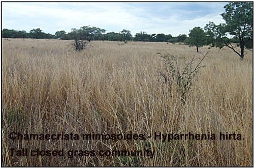
3. Chamaecrista mimosoides – Hyparrhenia hirta tall closed grassland community
The size of this plant community (Figure 14) is approximately 318.58 ha; in comparison with 2 plant communities is the smallest, located on the grassland of the Game Ranch. A total of 19 relevés were studied. The altitude ranges from 1351 m to 1400 m. The slopes are flat (0 to 3°) to gradual (4 to 8°). The geology that occurs in this community is granite and rhyolite (Figure 3). The landtype dominating this community is Ac 69 and smaller part on Fa 274 (Figure 4). The soil profiles identified in this plant community are Hutton, Katspruit and Clovelly. The soil depth is 450 to 750 mm (Figure 9) and percentage rock cover is low, ranges from 1 to 5 percent. Clay percentage ranges from 11 to 20 percent. Diagnostic tree species is Acacia tortilis (Species group R). Cynodon dactylon (Species group R) is a diagnostic grass species. Chamaecrista mimosoides and Richardia brasiliensis (Species group R) are diagnostic forbs. Terminalia sericea (Species group X), Rhus lancea and Rhus pyroides (Species group AE) are diagnostic trees species occurring in this community. Lippia rehmannii (Species group AD) is a diagnostic shrublet. Dominant grasses are Sporobolous pyramidalis (Species group Y), Aristida stipitata (Species group Z), Hyperthelia dissoluta (Species group AA), Perotis patens (Species group AB), Hyparrhenia filipendula (Species group AC), Sporobolous africanus (Species group AD), Digitaria eriantha and Eragrostis gummiflua (Species group AE), Hyparrhenia hirta and Aristida congesta subsp. congesta (Species group AG). Dominant forbs are Pavonia burchellii, which is exclusive in this community, Asparagus setaceus (Species group AA) Oxalis oblinquifolia (Species group AE). Chamaecrista mimosoides is more abundant in this community and is widespread in grassland (Van Wyk and Malan 1998). Cynodon dactylon occur in disturbed places (Van Oudtshoorn 2004). Hyparrhenia hirta is more abundant in this community, grows well in drained soil, open grassland as well as bushveld (Van Oudtshoorn 2004). Digitaria erianttha mainly grows in undisturbed veld. Eragrostis gummiflua grows in disturbed area and where water collects.
3.1 Bulbostylis burchellii – Melinis repens short closed grassland sub- community
The size of this sub-community is approximately 137.83 ha. The altitude ranges from 1330 m to 1350 m. The geology that occurs in this sub-community is mainly granite (Figure 3) and the landtype Fa 274 (Figure 4). The soil profiles identified in this sub-community is Clovelly. The soil depth is 450 to 750 mm (Figure 9) and percentage rock cover varies from 15 to 35 percent. The clay percentage ranges from 10 to 15 percent. There are no diagnostic trees, shrubs and grass species. Diagnostic forbs are Bulbostylis burchellii, Helichrysum coriaceum, Stylosanthes fruiticosa and Senna italica (Species group S) Dominant grasses are Setaria lindenbergiana (species group T), Loudetia simplex and Diheteropogon amplectens (species group W), Melinis repens and Eragrostis rigidior (species group AG). Bulbostylis burchellii usually occurs on rocky ridges (Van Wyk and Malan 1998). The grass species Melinis repens and Eragrostis rigidior occur in disturbed places, Loudetia simplex and Diheteropogon amplectens grows in poor gravely soil on slopes (Van Oudtshoorn 2004) and Setaria lindenbergiana grows against rocky ridges, between rocks and in shallow soils. Dominant grass species that occur in this sub-community indicate veld in poor condition.
3.1.1 Sporobolous pyramadalis – Hyparrhenia hirta Short closed grassland sub-community
The size of this sub-community is approximately 86.47 ha. The altitude ranges from 1305 m to 1350 m. The geology in this sub-community is rhyolite (Figure 3). The landtype that occurs is Ac69 (Figure 4). The slopes are gradual (4 to 8°). The soil profile identified in this sub-community is Clovelly. The soil depth is 450 to 750 mm (Figure 9) and percentage rock cover is 2 percent. The clay percentage ranges from 15 to 25 percent. There are no diagnostic trees species. Diagnostic grass species are Sporobolous pyramadalis, Eragrostis pseudosclerantha, and Elusine coracana (Species group Y). Dalechampia capensis, Gomphrena celesiodes, Datura strmonium and Tribulus terrestris (Species group Y) are diagnostic forbs. Dominant tree in this sub-community is Acacia tortilis (Species group R). Dominant grass species are Cynondon dactylon (Species group R), Hyperthelia dissoluta (Species group AA), Perotis patens (Species group AB), Hyparrhenia filipendula (Species group AC), Sporobolous africanus (Species group AD), Digitaria eriantha (Species group AE), Trachypogon spicatus (Species group AF), Melinis repens, Eragrostis rigidior, Hyparrhenia hirta and Pogonarthria squarosa (Species group AG). Chamaecrista mimosoides (Species group R), Oxalis oblinquifolia (Species group AE) and Mariscus congestus (Species group AG) are dominant forbs. Acacia tortilis is a small or medium sized tree with the crown typically flattened and spreading or umbrella-shaped. Acacia tortilis occur in bushveld. The leaves and pods which are browsed by game and stock are very nutritious (Van Wyk and Van Wyk 1997). Hyparrhenia hirta grows in well drained soil, especially gravelly soil in open grassland, as well as in the bushveld. The grass is seen as drought resistant grass which protects the soil and stabilises hard, gravelly soil and eroded places. Pogonarthria squarosa grows in disturbed places such as roadsides but also sparsely distributed in undisturbed veld. It grows mostly in sandy soil, but also in other well drained soils (Van Oudtshoorn 2004). Oxalis oblinquifolia is a perennial herb with long, slender, underground rhizomes which bear small bulbs. It is often occur in moist or disturbed places (Van Wyk and Malan 1998). The sub-community is dominated by grass species, low occurrence of trees and low rock cover of 2 percent. The sub-community appears to be disturbed in moist area.
3.1.2 Pavonia burchellii – Hyperthelia dissoluta Tall closed grassland
The size of this sub-community is approximately 39.54 ha. The altitude ranges from 1360 m to 1400 m. The geology in this sub-community is rhyolite (Figure 3). The landtype that occurs is Ac69 (Figure 4). The slopes are flat (0 to 3°). The soil profile identified in this sub-community is Katspruit. The soil depth is 450 to 750 mm (Figure 9). The clay percentage ranges from 15 to 25 percent. There are no diagnostic trees species. Diagnostic grass species is Hyperthelia dissoluta. Pavonia burchellii and Asparagus setaceus are diagnostic forbs.Dominant tree is Rhus lancea (Species group AE). Dominant grasses are Cynondon dactylon (Species group R), Perotis patens (Species group AB), Sporobolous africanus (Species group AD), Digitaria eriantha and Eragrostis gummiflua (Species group AE), Melinis repens, Eragrostis rigidior, Hyparrhenia hirta and Pogonarthria squarosa (Species group AG). Chamaecrista mimosoides (Species group R), Lippia rehmannii (Species group AD), Oxalis oblinquifolia (Species group AE), Tagetes minuta and Mariscus congestus (Species group AG) are dominant forbs. Rhus lancea is a small to medium-sized evergreen tree. The wood is reddish brown, hard, tough and durable (Van Wyk and Van Wyk 1997). Digitaria eriantha grows in sandy and gravelly soil in damp soil such as beside the vleis in areas with high rainfall. It utilises a wide range of other habitat types, however. It mainly grows in undisturbed veld. it is a palatable grass that is regarded as one of the best natural pastures. Its dominance in a veld is an indication of good veld condition (Van Oudtshoorn 2004). Mariscus congestus is an erect unbranched perennial herb. It occurs on moist and marshy places (Van Wyk and Malan 1998). This sub-community is located on the water catchment habitat.
3.1.3 Hyparrhenia filipendula – Eragrostis rigidior tall closed grassland sub-community
The size of this sub-community is approximately 54.74 ha. The altitude ranges from 1300 m to 1350 m, the slope is gradual (4 to 8°). The geology that occurs in this sub-community is granite (Figure 3). The landtypes is Ac69 (Figure 4). The soil profiles identified in this sub-community is Hutton. Soil depth is 450 to 750 mm (Figure 9). There are no diagnostic trees and shrubs species. Hyparrhenia filipendula, Brachiaria dictyoneura Eragrostis trichophora and Lolium perenne (Species group AF) are diagnostic grass species.Dominant grasses are Eragrostis gummiflua (species group AE), Themeda triandra and Eragrostis rigidior (species group AG). Dominant forbs species are Chamaecrista mimosoides (species group R) and Tagetes minuta (Species group AG). Hyparrhenia filipendula is mostly found in bushveld regions, all types of soil, but more often in gravely soil where it can form dense stands (Van Oudtshoorn 2004). Brachiaria dictyoneura is perennial tufted grass occurs in bushveld, damp sites and often along road reserves. Themeda triandra is abundant in undisturbed open grassland and bushveld in part with an average to high rainfall. (Van Oudtshoorn 2004). The sub-community is located on water-catchments area. ORDINATION The distribution of the 100 relevés along the first (X) axis and the second (Y) axis of a Detrended Correspondence Analysis (DECORANA) diagram is represented in Figure 15. A definite gradient in rock cover is illustrated along the X axis. Sub-communities situated to the left of the diagram are associated with very low to absent rock cover. Sub-communities situated more to the right of the diagram are associated with very rocky conditions on the mountains areas of the ranch. The sub-communities are clearly shown in the diagram.


Figure: The scattered diagram of relevés along the rock cover gradient of a DECORANA ordination for the plant communities of Highlands
Management units
The essential strategy to improve wildlife management measures such as periodic burning is to divide the game ranch into management units that are large enough to manage. Small plant communities are not easy to manage when they are scattered as a mosaic and when they are not bordered by roads. Plant communities or sub-communities that are similar are managed as group. A dendrogram derived from TWINSPAN was used to derive management units for Highlands Wildernis Game Ranch (Figure 16). With help of roads, five management units were created (Figure 17). The management units were drawn on a map and surface of the management units were calculated (Table 3). Plant community one is the largest, covering most parts of the ranch. The plant community is divided into management unit 3, 4 and 5. All 3 sub-communities of plant community 1 are included. Management unit 1 include plant community 3.1 and 3.2, which are characterised by grassland and water catchments areas. Plant community 2.1 is entirely a component of management 2.

| Management unit | Size (ha) | |
| 1 | 178.68 | |
| 2 | 234.86 | |
| 3 | 221.70 | |
| 4 | 407.55 | |
| 5 | 188.48 | |
| Total | 1231.25 |
Management unit 2 is dominated by steep slopes and high rock cover. Small sub-communities like 2.2 and 2.3 that are close can be combined and managed as one unit. To monitor changes in vegetation, one monitoring site (Figure 17) was allocated in each management unit, except in management unit 4; two monitoring sites were allocated because of large size and signs of over-utilisation on the management unit. Monitoring is a continuous process and should be done wherever management is applied.
Conclusion
The Braun-Blanqet survey technique was used to analyse the vegetation at Highlands Wilderness Game Ranch. With the synthetic phase of the Braun-Blanquet method, using TWINSPAN, the distinct homogeneous vegetation units were identified on the basis of similarities in vegetation composition and structure. From this, three plant communities and thirteen sub-communities were identified on Highlands Wilderness Game Ranch. Detrended Correspondence Analysis (DECORANA) was used to identify the environmental factors responsible for the creation of the different plant communities. The moisture content of the soil, clay percentage, terrain and the amount of rocks are the most important factors determining the existence of the communities. Variations in community composition can be explained by the enviromental variables.
References
BOTHMA, J du P. 2002.
Game ranch management. Fourth edition. Van Schaik, Pretoria.
EDWARDS, D. 1983.
A broad-scale structural classification of vegetation for practical purposes.Bothalia. 11: 705-712.
Hil, M.O. 1979.
DECORANA – a FORTRAN program for detrended correspondence analysis and reciprocal averaging. Dept. Of Ecology and Systematics. Cornell University, Ithaca, New York.
JOUBERT, S.C.J. 1996.
Animal behaviour. Pp. 160 – 166. In:Bothma, J. du P. (Ed.). Game ranch management. Fourth edition. Van Schaik Publishers: Pretoria.
KENT, M. and Coker, P. 1996.
Vegetation description and analysis. A practical approach. John Eiley and Sons Ltd. England.
STUART, C. and Stuart, T. 2001.
Field guide to mammals of southern Africa. Struik Publishers (Pty) Ltd. Cape Town.
STUART-HILL, G.C. 1989.
Adaptive management: the only practicable method of veld management. Pp. 4 – 7. In: DANCKWERTS, J.E. and Teague, W.R. (eds.). Veld management in Eastern Cape. Department of Agriculture and Water Supply, Eastern Cape region, Sutterheim.
TAINTON, N.M. 1999.
Veld management in South Africa. University of Natal Press, Pietermaritzburg.
VAN OUDTSHOORN, F. 2004.
Guide to grasses of southern Africa. BRIZA publications.Pretoria.
VAN ROOYEN, N. and Bredenkamp, G. 1996.
Sour bushveld. In:Low, A.B. and Rebelo, A.G. (Eds.). Vegetation of South Africa, Lesotho and Swaziland. Department of Environmental Affairs and Tourism, Pretoria.
VAN ROOYEN, N. 2002.
Veld management in the savannas. pp. 571-620. In: Bothma, J. du P. (Ed.). Game ranch management. Fourth edition. Van Schaik Publishers: Pretoria.
VAN WYK, B. and Malan, S. 1998.
Field guide to the wild flowers of the highveld. Struik Publishers (Pty) Ltd. Cape Town.
VAN WYK, B. and van Wyk, P. 1997.
Field guide to trees of southern Africa. Struik Publishers (Pty) Ltd. Cape Town.
WERGER, M.J.A. 1974.
On concepts and techniques applied in the Zürich-Montpellier method of vegetation survey. Bothalia, 11(3): 309-323.