Introduction
An extensive oasis of relative calm compared with the open sea across Chesil Beach, the Fleet Lagoon is a vital shelter and feeding area for wildlife. This long, shallow stretch of water is England’s largest lagoon at around 480 hectares. Home to the famous Abbotsbury Swannery and large numbers of over-wintering Brent geese, the Lagoon draws wildlife watchers to its shores. Visitors can also see other resident and migrant birds like little terns, wigeon, pochard, coots, even an occasional passing osprey.
In addition to its birds, the Fleet Lagoon Marine Protected Area also protects numerous plants and animals. Several marine plants like seagrasses, stoneworts and salt marsh, and animals like lagoon sandworms, lagoon sand shrimps and the rare DeFolin’s lagoon snail all benefit from the Fleet’s status as an MPA.
The Fleet Lagoon is also an important nursery area for several types of fish like bass, black bream, sand smelt, mullets and gobies. Commercial fishing does occur in the Fleet although it is tightly controlled and limited in its extent. Toward the seaward end, oysters are also farmed commercially.
Chesil Beach provides a protective barrier for the Fleet Lagoon, shielding its waters from waves, swell and storms gusting up the English Channel. The beach is an iconic part of the Jurassic Coast whist the Fleet Lagoon supports rare wildlife populations as well as the famous swan herd at Abbotsbury Swannery.
Protected Features
The Fleet Lagoon MPA has a number of specific protected habitats and species that are monitored to ensure they remain in good, healthy condition and are not adversely affected by human activities. These protected features are described below.
.


Seabed Features
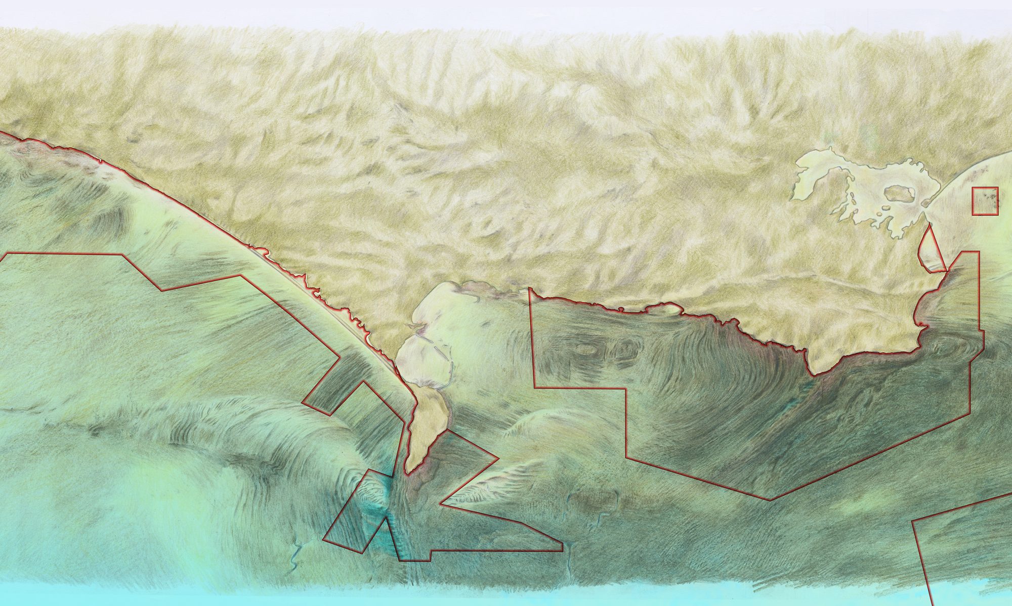
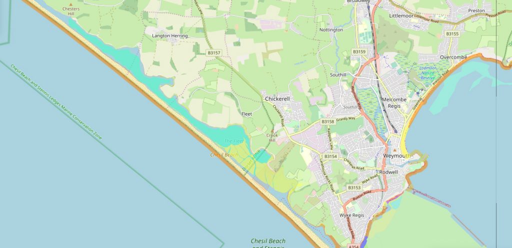
As described on the previous page, the Fleet Lagoon is thought to have been formed some 5,000 to 7,000 years ago. Chesil Bank was driven slowly shoreward by rising sea levels and bolstered via longshore drift of gravels from east Devon’s crumbling cliffs. Chesil Beach made landfall and now the only remaining direct access to the sea from the Fleet is via the narrow channel at Ferry Bridge at the southern end.
Much of the Fleet is very shallow with depths above ‘The Narrows’ no more than 2m, often less. The tidal range is only around 1.5m on a big tide – very small when compared to the tidal range over 4m in Chesil Cove for example. Being so shallow and with a narrow entrance to Portland Harbour at Ferry Bridge, the tidal range can be very unpredictable due to the greater influence of wind strength and direction and atmospheric pressure.
With minimal freshwater input and percolation of seawater through the shingle bank, the lagoon remains saline for much of its length, although salinity becomes lower and more varied toward the northwestern end. Percolation is the process by which sea water seeps or is forced through the shingle bank of Chesil Beach at high water and during storm events. Occasionally seawater enters by waves over-topping the beach.
During storms seawater can be pushed through the beach with such force it creates ravines or gullies in the shingle known as ‘canns’. During big storms, water can be seen flowing through the canns. If the canns become inactive they can become overgrown with plants which help stabilise the beach structure.
You can examine the canns opposite Langton Hive in detail via the 3D model shown here.
The lagoon is 900m wide at its widest point near Littlesea and just 65m wide at The Narrows by the Army Bridging Camp. In the shallower areas with lower water currents, the seabed is characterised by muds and fine sands. However in the deeper tidal channels and narrow parts of the lagoon, the faster flows experienced with each tide wash the sediments clean and they can vary from coarse sands and gravels to pebbles and rockier habitats. Each different sediment type supports different species of plants and animals.
The Dorset Integrated Seabed survey (DorIS) map shown on the other pages does not extend into the Fleet Lagoon.
Despite lack of DorIS data, a map showing the main habitats and communities in the Lagoon is available to see on the European Marine Observation and Data Network website.
The images below show the varying depths and channels within the Fleet Lagoon as well as the canns through which salt water is forced through the beach into the lagoon. Also clearly visible are the seagrass beds and algae communities throughout most of the shallow water areas.
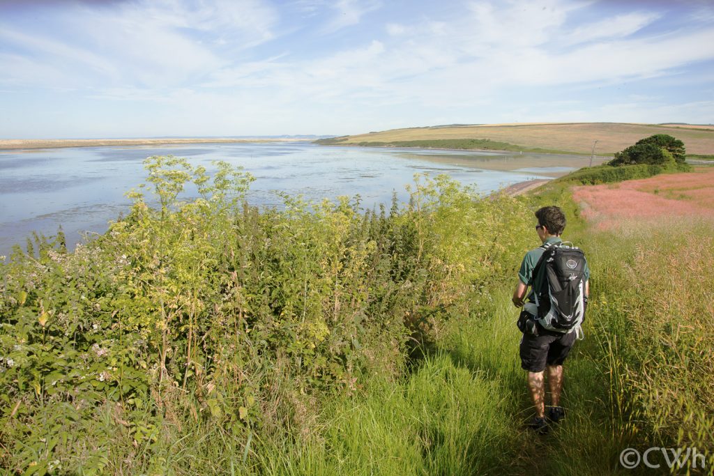
The Fleet Lagoon is well-known for its birdlife. In addition to the resident herd of swans which frequent the Abbotsbury end, the site supports large numbers of widgeon and brent geese during the year whilst little terns nest on Chesil Beach and feed in the lagoon. Beneath the surface the Lagoon’s aquatic life changes along its length depending on the depth, substrate, current and salinty.
Image: Charlie Wheeler
Habitats and species
The wildlife of the Fleet Lagoon is its greatest asset. Much of its predominantly rural shoreline has been owned and managed by the Ilchester Estates for the past 400 years.
The Fleet is saline (salty) for most of its 13.1 km (8.1 mile) length, although this varies toward the Abbotsbury end away from its connection with the sea at Ferry Bridge. Rain, wind, tides and over-topping waves all affect how salty the water can be at any given time and place. The variable salinity means that only plants and animals which are tolerant of such conditions can flourish in the Lagoon’s waters.
Part of the rich tapestry of wildlife within the Fleet Lagoon includes extensive seagrass beds to the west of The Narrows and toward Clouds Hill (west of Rodden Hive). Seagrass begins to grow in spring and reaches high densities in summer through until autumn when it dies back. The seagrass is found in soft sands and muds and four different species live in the Fleet Lagoon – Zostera marina, Zostera noltei, Ruppia maritima and Ruppia cirrhosa. The foxtail stonewort Lamprothamnium papulosum is also found in dense patches either alongside or mixed in with the different seagrass species.
The images in the galleries below give an idea of life in the Fleet’s seagrass beds and elsewhere in the lagoon where it narrows and water flows faster creating a different, dynamic habitat. The word cloud provides links to some of the more commonly recorded species inside the Fleet Lagoon MPA.
The Fleet Lagoon
ROLL over each image to find out more. CLICK on each image to see a larger version. ESC to return to the main screen.
TAP each image ONCE to find out more, TWICE to see a larger version. Tap off the image to return to the main screen.
return to the main screen.
The Narrows – where the Fleet meets the sea
In the Narrows the Fleet is only around 65m wide. On an out-going tide all the water from further up the Fleet rushes through this area. The faster flowing water keeps the seabed cleaner, providing a living space for different plants and animals to flourish.
ROLL over each image to find out more. CLICK on each image to see a larger version. ESC to return to the main screen.
TAP each image ONCE to find out more, TWICE to see a larger version. Tap off the image to return to the main screen.
return to the main screen.
Pinch point
The narrow entrance to the Fleet Lagoon where it meets Portland Harbour is at Ferry Bridge. Here, up to four times a day the lagoon must be emptied or filled by the tide. The currents are strong and allow different species to thrive – colourful sponges, anemones and algae tolerant of such conditions. Colin Garrett’s video below shows the colourful communities that live beneath the bridge.

The Fleet Lagoon is steeped in history and takes its name from the Saxon word ‘Fleot’ meaning ‘shallow water’ .
Image: Lin Baldock
People and management
Shallow water with variable temperature and salinity means fewer kinds of fish and other marine life can live in the lagoon compared with the adjacent coast. Whilst this inevitably limits the value of the lagoon’s waters for commercial fisheries, certain small-scale fisheries date back centuries, and continue to operate today.
Take a stroll along Chesil Beach (outside of the ground-nesting bird season) and you are sure to come across signs of historical fishing activity. A small number of disused ‘lerrets’ can be found on the beach. These wide, flat-bottomed, double-ended fishing boats were designed to allow seine nets (used to catch mackerel) to be set over either side without needing to turn the boat around and to allow easier retrieval back up the beach.
As well as being important fishing vessels, the stability and good buoyancy of the lerrets gave them another key role. Lerret crews often risked their lives, launching into rough seas to rescue mariners in trouble in stormy seas.
Fishing today
Only a very low level of fishing activity occurs within the Fleet Lagoon, mostly toward its southeastern end.
The lagoon is used by a small number of commercial net fishermen who target grey mullet and occasional herring or mackerel. One further vessel uses pots to catch green shore crab (Carcinus maenas) to be used as bait. The Fleet also supports a small fishery for the European eel (Anguilla anguilla).
The Fleet Oyster Farm is a small-scale aquaculture operation based at the eastern end of the Fleet, covering approximately two hectares. The farm grows Pacific oysters (Crassostrea gigas) mostly for consumption in local restaurants. The aquaculture rights for the site are leased by the landowner, Ilchester Estates.
Chesil beach’s shores are a popular location for recreational sea angling on the seaward side of the beach. A limited amount of angling occurs inside the Fleet between Ferry Bridge and The Narrows. Anglers may also dig occasionally for bait on the mudflats around Ferry Bridge.

Partial solar eclipse over the Fleet Lagoon, 2014.

Other sea users
The unique physical nature of Chesil Beach and the rich wildlife of the Fleet Lagoon and surrounding areas attract up to 150,000 visitors a year, mainly for recreation and educational purposes. Bird watching, sea angling, walking, field trips and general site-seeing visits to Chesil Beach are among the many reasons people visit the Fleet.
One of the main draws to the Fleet is the Abbotsbury Swannery at its far end. The 600-strong herd of swans, established by the Benedictine monks has been present for almost 1,000 years and is managed today by the Ilchester Estates.
Diving in the Fleet is rarely undertaken owing to the very shallow waters. Some divers do occasionally enter the Narrows next to the Army Bridging Camp and drift on the ebbing tide toward Ferry Bridge. The dive offers something different to the usual wrecks and reefs along the coast. But divers must be wary not to get stranded on shallow muds and should watch out for strong currents and boat traffic at the end of the dive around Ferry Bridge.
Management in a nutshell
‘Chesil Beach and the Fleet Lagoon’ is recognised as an area of high conservation value through the many national and international designations it is afforded – SSSI, SPA, SAC, Ramsar and being the centre of the Jurassic Coast World Heritage Site. The Fleet and Chesil Reserve is managed by a warden, employed by the Ilchester Estates and a reserve management meeting is held biannually attended by relevant stakeholders, authorities and organisations.
The EU Habitats Directive and EU Birds Directive set out how the site as a whole should be protected and managed. Management of European Marine Sites (SACs and SPAs) is the responsibility of all competent authorities which have powers or functions which have, or could have, an impact on the marine area within or adjacent to a European Marine Site (EMS).
Natural England leads the management of the site due to its designation as a Site of Special Scientific Interest (SSSI) and provides information on the condition of protected habitats and species.
The Fleet Study Group is a small, independent organisation of volunteers with research interests in the Fleet, whilst Southern IFCA and the Environment Agency undertake annual spring and autumn fish population monitoring at various sites within the lagoon.


The low level of fishing operations in the Fleet mean only a few management measures are required.
Intertidal hand-gathering
The low level of bait collection and shellfish hand-gathering for personal use from the mudflats close to Ferry Bridge is not considered to present a risk to the Fleet Lagoon. As a precaution to minimise the disturbance to ground nesting birds, Chesil Beach is closed by Ilchester Estates between 1st May and 31st August between the Tank Teeth at Abbotsbury and the Portland Boundary Stone. Bait-digging and hand-gathering are prohibited between The Narrows and Abbotsbury under the Southern IFCA ‘Prohibition of Gathering (Sea Fisheries Resources) in Seagrass Beds’ byelaw.
Net fishing
Fewer than six fishing vessels are licensed to fish with nets in the lagoon using pound nets – a kind of gill nets which are set in a circular motion around a shoal of fish. These mainly target grey mullet species, occasionally catching herring or mackerel. The lagoon has a year-round designation as a bass nursery area so any bass caught must be returned immediately.
Net fishers must comply with a series of minimum conservation reference sizes for fish species, outlined in European legislation and Southern IFCA byelaws. These include a larger local minimum size for grey mullet species. Alongside their review of net fishing management, Southern IFCA plans to review the suitability of the minimum size for grey mullet species, with the potential for greater alignment with the species’ size of sexual maturity.
Fyke net fishing
Fyke nets are used to catch European eels within the Fleet. This activity is managed under licence from the Environment Agency.
Pot fishing
One vessel pots occasionally for green (or shore) crabs in the lower Fleet, east of The Narrows. These are mainly used for bait in other fisheries. This pot fishing is restricted in terms of its size and seasonal operation and monitored by Natural England.
Sea angling
Angling in the Fleet west of the Narrows is not permitted by Ilchester Estates. The Fleet is a designated year-round Bass Nursery Area, bringing restrictions on the use of baits by anglers fishing from boats. All anglers must comply with the minimum species landing sizes set out under Southern IFCA byelaws.
Dredge and trawl fishing
No towed gears are known to be used in the Fleet and Southern IFCA has introduced management to prohibit bottom-towed fishing gears west of The Narrows.
Looking to the future
Natural England is responsible for monitoring the Fleet Lagoon and its protected features. If any evidence arises about potential impacts to these features from commercial fishing, Southern IFCA (or the Environment Agency for the eel fishery) would assess the evidence and consider the necessary management response.
In 2018 Natural England classed the Coastal Lagoon feature as ‘unfavourable / declining’ due to seagrass die-back that occurred in 2016 / 2017. Reasons for the dieback were unclear – it might be due to nutrient input to the Fleet from the surrounding land or be related to the winter storms in 2014. The latter could have washed seagrass seed out of the Fleet. Some recovery has been observed since 2018 and monitoring continues.
It is essential that all fishers are aware of existing regulations and understand the reasons behind them. Southern IFCA works to improve awareness and understanding via active engagement with all fishery sectors. Compliance with the regulations is monitored during patrols by Inshore Fisheries and Conservation Officers (IFCOs). The catches, landings and fishing gears of vessels, anglers and divers can be inspected. Non-compliance can result in warnings, financial penalties or prosecutions.
During patrols and inspections IFCOs can update fishers on any regulatory changes. Patrols also provide opportunities for fishers to discuss the status of local fisheries with IFCOs and to make their own management suggestions.
Further protection for the Fleet may be added towards the end of 2019 as a part of the Southern IFCA’s netting review.
Meetings through groups such as the Dorset Coast Forum, Dorset and East Devon Fisheries Local Action Group (FLAG), Dorset Wildlife Trust and Southern IFCA continue to ensure that stakeholders and regulators engage with one another on a regular basis. The MPA Community Planning project funded by the Dorset and East Devon FLAG is one such project which held initial workshops in 2018 to engage with the various groups using MPAs and help shape future management plans.
The on-going monitoring, enforcement, education and discussion aims to ensure healthy and productive local seas are secured and improved for future generations.
Image: Charlie Wheeler